Wednesday 24 September 2008

Shetland in Autumn

Watch this space....

Isles of Scilly to Sennen Cove 7th Sep 08

Weeks of unsettled weather & a period of illness suggested the best course of action would be to cancel my leave & wait for more suitable conditions in order to do the reverse of last years route [posted on SESK:-
Isles of Scilly to Longships 13th Sep. 07]
Sennen Cove to Great Ganilly island/ Isles of Scilly was the plan for Sep. 8th & arranged some months ago with Colin who was keen to do the route while he was over here from France. My aim was to do my solo thing well in advance & then join Colin for a second outing, but thanks to the weather
I couldn't fit it in.
The original plan for was for 3 in the group & we were disapointed when Mark Sky had to pull out due to employment commitments & for a while it
looked like I would be too to unwell to do the route leaving Colin with a solo trip in conditions, as it turned out, that may have been considered
unsuitable. Leading up to the 8th Sep. the weather was pretty awful but always the poss. of a 'window' at some stage that would suite us but it meant being on hand to go at short notice, & with that in mind Colin & I headed off to Penzance shortly after we noticed a possibility due within a day or so. Wind direction & strength was all in favour of the route out from the Scilly's, not our intended direction but at least something.
We of course arrived in Penzance with conditions ideal for our prefered route out to the Scilly's......it happens that way sometimes, too late for that & no other choice than to take the ferry out to the islands & do the alternative route in the forecast window if & when it appeared.

At St Mary's with plenty of beach to load the boats & with protection from the wind, we launched with a bright sky to the north & headed out past the quay hopeful of a pleasant but breezy trip out to the Eastern Islands, but once clear of the harbour in open water the sun went home behind a very dark sky & the wind velocity increased.
Overnight protection from the weather was the main priority, & with the wind speed still increasing from nnw we agreed to to go over to Tresco as a first option & while ashore view the sea conditions towards the north from the high ground up from the beach. From what we could see it looked reasonable & with the wind dropping we continued on to the outer isalnds to the east in order to check the beach conditions on Great Ganilly. Colin spotted a section of beach earlier with good protection for the night at the top of the beach, so after a trip around Great Ganilly island we went back to Great Arthur island & went ashore for the night.
Through the night we monitored the wind speed & direction for any pattern, trusting in the forecast for an eventual westerly by the early hours, but my devise indicated a mainly north wind with at best 30 degrees
in our favour & way above the 10n in the met office report.
We let the early morning launch time time go by & agreed to wait-out the day for favourable conditions with the evening tide. By 3pm it looked promising, the night before hinted of a red sky, & as it prooved the day was bright, sun & a few white clouds but 15n windspeeds gusting, but it was dropping so we made ready & headed out with the intention of being on the start line for 4.30pm. Ckecking sea conditions as we moved into more open water, nearing the line of departure between Gt Ganilly & Gt Arthur islands the wind speed dropped to just a few knot's.

Having completed the route myself last year this was Colin's trip so to speak, to plan his route as he thought best, with just a couple of minor items of local knowledge I gained the year before. So as the start line went past & with his GPS running & set to log the route to the Longships light we continued on into deeper water, observing the surface swell out to the horizon, it looked ok, with no visible major white horses. Not entirely certain it was 'on', the wind dropped to no more than a breath......both very suspiciouse, Colin called out..."Are we going"...."Yep" came the reply & with skeg fully down to counter the quartering sea from port aft' we went on with a sea swell that was sustained throughout the trip, 2m peaking 3 with a few mildly breaking waves.
Start time was 4.30pm & it took a further 500yds or so to confirm we were in deeper water & free of the shallow seabed profile of the land, & as it looked, fully exposed to the maximum sea conditions that unless the weather deteriorated, would probably remain that way for the passage to Sennen Cove.

The aim was to get through as much of the shipping lanes as poss. before nightfall & the pace set by Colin was what was needed & I was pretty disapointed at not being able to meet it, a couple of weeks off from hard paddling would have seen me in far better shape after 6 weeks illness.
The sky to port, star'bd & foreward was marked with a variety of weather systems, minor anvil clouds, higher winds at altitude & as Colin pointed out, clear sky's on the windward side over our shoulders.

Sunset was due 6.30pm between Lat. 48 & 50 & we were in darkness as we aproached the eastern extreme of the south bound lane having observed about 5 commercial vessels up till then, all passing through ahead of us. Later, approaching the line of departure from the shipping lanes the vessel we observed at 2.5 miles going around Gwennap Head enroute to the separation zone, took the shortest course & passed astern of us at us at 800yds showing green all the way. A short time later the vessel steaming south ahead of us 500yds was a large commercial fishing vessel in the inshore traffic zone with workdeck illumunated & the regulation several sqaudrons of seabirds in attendance.
During the run through these lanes my main light failed & my reserve 'C' light became caught-up in tag lines to other equipment....raffting I could have freed it but that meant wasting valuable time so I did the best I could by heaving it into the best position poss. & no option for cutting it loose in the sea conditions together with the poss. of seeing it go over the side. I made do but annoyingly Colin could not see my light all of the time.
We were on target for the Longships light, well visible from berfore dusk, & the other good thing about this shipping hazard is it is located a mile out from Land's End.......an excellent reference point to course & position as it moves port or star'bd against the lights from the headlland behind while negotiating that section in the tidal sequence when it devides into 2 as it heads into Land's End. Colin's colour printout of the track/log indicate a couple of sharp course corrections he made which coinside with my view on the night of the Longships light moving to star'bd & then to port, we were in that thin line between the north & south running streams that can take you by suprise.
The Longships light took ages to grow in height & when it did it seemed to happen all at once as we neared, passing the lighthouse a few hundred yds to our star'bd the outline of the rocks could be seen with the steady hum of the swell rolling through the shallows. Closer-in, the dip in the headland could be seen to the north of Land's End against a hint of light from buildings in Sennen Cove.
Almost upon the final run-in to the cove, Colin, true to his GPS settings maintained his course in order to safely clear the land on the edge of Sennen Cove....safe now, & with local knowledge I steered a course closer-in & direct into the cove thinking at one stage I may have been a little bit bold when a larger than average one went smacking into the rocks over to my right.
Nearing the lifeboat station it was time to relax, & a little later we both glided up the beach on a 1m surf on an illuminated secion up by the car park.....the "Yarhooo" over to my right indicated Colin enjoyed the coming ashore.
It was a nice way to end the trip.

Colin recorded speeds of 5.7n running with the swell & 1.3n in the troughs.
My under par physical condition combined with the sea conditions added time to the schedule but other than that it was a great trip, good vis. a breath of a breeze all the way & a great landing in Sennen Cove: unlike last year, in wonderful conditions, I landed at the troublesome far end of the cove in order to be alone & sat in my kayak feeling satisfied when I should have got out & pulled my boat clear.....I didn't, & a large one sneaked up on me & sucked me back down the beach & knocked me out of my kayak. A local enquired if that was the usual way that kayakers came ashore, I said "no.. it's a warm evening & I've had a good hard paddle, thought I would cool-off a bit".

As I mentioned, this was Colin's trip, with his enhanced GPS devise & tracking software installed on a PC back in France, it was a fine demonstration of available technology put to very good use....I'm lucky if I remember to include a basic GPS in my kit, but with the result of Colin's work, our passing through a difficult section of tidal stream which in poor vis. could be dodgy, I too could be persuaded to invest in a GPS that has the capacity to download chart software.
----------------------------------------------------------------
I knew Colin was coming over from France with his new boat, a Reval Viking, so I got one from Peter at Shoreham Seakayaks in time for the trip, so this was my first outing in the new boat, it incorporates a much faster hull design that I have encountered before, with just enough angle on the bow to provide excellent edging capabilities. With a generous skeg in the difficult sea conditions encountered, the Viking pointed beautifully at all times. Colin's was fitted with a rudder too & I know, like me, he is over the moon with this kayak.

October ?.....we are all due some descent paddling weather, & with 2 weeks leave booked for a few days exped. I have written-into the arrangements the right to depart for Penzance at short notice to do the route out to the Scilly's......there's time yet, with luck.

---------------------------------------------

Taking part: Colin Appleby & Mike J.Smith.

Dorset Coast 20/21 September

i went i saw i paddled a bit further than planned....
i started out a bit late thanks ironically to the southampton boat show, so my intended 15k paddle from lulworth to chapmans pool was a no go so late in the day , 4.00pm before i had boat packed and on the water. admittedly not just the traffic, i did head down to check out Chapmans pool on foot as i had never camped there before thought this might be prudent. For this late start and a couple of other reasons no overnight parking around Studland being not the least of the flaws in my plan. I decided to start out from Kimmeridge and have a short paddle round to `Chapmans Pool 4k (i think), camp overnight on the beach, and then paddle a bit more on the sunday morning round to studland then to hitch back to pick up the car.

So with that as the alternative plan I headed out ,against the tides (and wind)douh! not to big a problem I can cope with that for a few k!. I was at chapmans Pool within an hour so as i wasnt quite ready to come off the water, I paddled a bit further round past St Aldhelms Head in mixed, choppy, twisty, and slightly unsettling water, not to bad heading out but the return journey was more of the same, but with the tide and a tail wind,
this seemed to make for a less stable and more surfey paddle, (does every body else feel more stable paddling into wind or is that just me?).

Those first few hours of paddling look like about 10k on map, then back to the beach to set up camp, and gather some of the driftwood i spotted earlier on in the day. Now i could make a nice big fire to keep me warm, Normally i dont do fire, the latent arsonist in me has never been as adept as i was at age 10, when it only needed the combination of me, a mate, and a box of matches, to get within a mile of a field of corn stubble for the whole of East Anglia to spontaneously combust. These days i have trouble getting a Trangia to stay alight, it took me an hour and a lot of matches to remember that a nice pile of dry tinder is a very desirable component of the whole fire lighting process, once i twigged this things got a lot warmer and also smokier.

Still I was happy I had satisfied my deep inner need to hunter gather, and was happily sat on the beach incinerating every bit of driftwood i could lay my hands on. Pasta and dodgy Dolmio sauce had been cooked and scoffed.

The stars were copious the moon was rising behind the cliff, and the waves were gently cascading through the gravel just a few yards away from my camp.....hmmm what time was high tide tonight?, thus the next few hours till midnight were spent with a half awake half asleep one eye on the encroaching waves state of semi doze. It did get a little chilly in in the wee small hours, I could have made very good use of a sleeping bag liner for that little bit of extra warmth, but no frostbite so it cant have been that cold.

The cold did serve to wake me early enough to watch three guys paddle into Chapmans Pool and over to my little stretch of gravelly paradise. They bid me a "good morning" and "did you sleep here allnight!!!!?" and to me the slightly envious tone in their voices was clear, when i confided what my plans for the day might be, "sounds like a great day shame we have to get back home to the familly, only been able to get out for a couple of hours have to be home by 10am" these 3 would be the only other kayakers that i would meet until i got back into kimerage at the end of the day.

A quiet moment or two as i packed my boat and made breakfast and coffee, well pseudo coffee, filter bag in a foil pack drinkable but not really coffee as we know it. Breakfast was only a bunch of cereal bars and cheese sarnis made with warm pitta bread (Thanks to Angie for that tip "pitta packs smaller and travels better than a loaf").

The wind had freshened a little and had swung around to a more southerly direction. I was fed the boat was packed and by 8.30 we were both back on the water. I had decided overnight that i didnt fancy the potential 12k walk back to the car from Studland should I fail to Hitch a lift, and lets face it who in there right mind would pick up a hairy damp disheveled kayaker late on a sunday afternoon? (i would but i was in a kayak not a car).

So my choice was to either paddle round St Aldhelms Head into swange then back to Kimerage to pick up the car or to head straight back to Kimerage then paddle up to lulworth for what passes for a cup of coffee around here, then return to Kimmeridge the car and join the cues on the way back to london.

Lulworth won out in the end mainly because of the state of the water around St Aldhelms Head was far worse than the previous evening I would have been happy going round once but wasnt keen on the trip back.

lulworth via kimmeridge was the winning choice and anyway I thought it wouldnt be all that far just a few K on from Kimmeridge to lulworth isnt it....? I didnt have that bit of map with me. It didnt even dawn on me when I chatted with the local fisherman "morning a nice night to sleep under the stars"and "you going far today?" My reply was "oh not so far, no further than Lulworth then back to kimmeridge..." i should have guessed from the the raised eyebrows and the "you must paddle quite fast" and when I added "just a couple of hours worth of paddling" the look of knowing that came in reply should have set the alarm bells ringing.

I left the bay at 8.45am, and headed out into the again wrong way tide, and the stiffening headwind, thinking i had no more than about 7-8k till I could order up a cappucino dans le tasse de polystrene. As my watch was keen to point out to me 4 hours later "if that was 8k im a rolex" I was definetly getting slower, it may also have been all the false lulworths along the way Brandy Bay, Worbarrow Bay, Mupe Bay, it may even have been the fact that i was having a great time and with the inner peace and calm that comes from paddling on my own ,the distance and time just melted into one.
I think it has more to do with me being a little usless in the morning without a decent shot of caffine, so with low flying gulls shags/cormerants, (never sure which is which just that nobody ever fancies a quick cormerant...) and a happy smile i worked my way along the coast about 500 meters off shore, trying to avoid the confusion of waves, chop and back wash, rebounding off the cliffs and underlying edges. I did eventually make it to lulworth and the Confusion of day trippers who come there through the brick hell that passes for a visitor center expecting a nice day of sandcastles and deckchairs on the beach only to find that the tide is in and the beach wont be back till they are sat in their cars heading home.

After the polystyrene clad caffine injection was downed it was time (1.00pm) for the return journey oh and guess what the tides had once again turned "bugger" not only that but wind was now back to the easterly i had made friends with the day before "double bugger" It was 3.30 before I finaly made it back into Kimmeridge but I was so pleased i went out this weekend i was close to not going when I couldnt find anybodyelse to paddle with yes it would have been good to have company but i think it would have been a completely different trip not in a bad way but it would have been different, yep a few things could have worked better like my tide and distance calculators but there were some that could never be improved like the sublime sunset over Chapmans Pool and a perfect beach bivi with driftwood fire to keep me warm.

Now im back at my work desk and ive still got that on the water feeling the bobbing will die down in a couple of days but for now i have big smiles.
Hope I get to share the next trip with some or all of you.

St Lawrence to Maldon 14th September

I thoroughly enjoyed the trip on Sunday, even though this is local home waters to me. I rarely go so far up stream. I would normally launch further east with Osea island or the stone pub being as far upstream as I would go.

Everybody arrived pretty much on the dot, as said above it was local (within 25 miles) for me, it was Johns turn to do the driving all the way from bucks this time. On arrival the slipway that I had intended to use was closed off with six ft metal gates and a hefty padlock. A quick word at the adjacent sailing club enabled the access to the beach via their slip. The sailing club were in the process of setting up a power boat / water-ski race day, something that I have never come across on the Blackwater before. I wasn’t disappointed that we were going in the opposite direction. The weather was good, slightly overcast but no rain, wind was slightly stronger than expected at a force three coming from the east which later picked up to a low four.

The paddle out was quite a straight forward affair, with low following waves. Being local and enclosed water, I had only planned the route in the loosest of ways, out around the top of the islands and back around the bottom. As we came around Osea island, the route around the top of Northy island is far from obvious, being hidden amongst the far shore. We needed to adjust course slightly to the north. Just as well Rog knew were he was going, I continued to circumnavigate Osea. There were several dingy races going on from Heybridge basin sailing club and we had a short game of dodgems getting across the channel and over to Northy island.

As we came into the quay at Maldon the visitors pontoon was only partly occupied and a lot further out of the water than I remembered it from my last visit, about three years ago. I clambered out only to be told that there was a Thames barge arriving on the soon to be high tide. Back into the boat and around to Maldon prom which forms part of the town park.

A large traditional boat followed us into the quay which I noticed not to be of a local design.

A visit to Mr Google revealed it to be a 1980 build concrete hull replica, a bit like a big Caterham seven car. It’s a 70ft gaff rigged cutter, the originals being built in the late 19th and early 20th century, being used as fast dispatch vessels for the Royal Navy.

We decided to forego a lunch time drink and instead set off for the return journey slightly early a short while before the turn of tide. Just to pick things up a little as we left the protection of Northy island, wind was now against the tide for the two mile trip to Osea. At Osea we took a second short break, while, with some amusement we watched as a yacht came dangerously close to shore while seemingly struggling to tack. He was either lucky or knew his home waters very well. For the last two and a bit miles we decided to take the choppy route down the middle of the main channel where the white bits were. This led to quite a fun paddle though 3 maybe occasionally 4 ft, short and steep bouncy waves with plenty of spray and buried front ends.

At the end of the trip, Sitting on the sea wall outside the Stone pub, with pint in hand. The estuary is only about a mile and a half wide at this point, most of which is fairly shallow emptying out at low tide. This leaves a maybe 2or 3 hundred metre wide channel. It was quite interesting to see a classic case of wind against tide. In the shallower and slower moving areas there were a few waves but no broken water showing. Whereas the water ebbing quite strongly against the wind in the deep water channel looked (as we well knew) to be decidedly choppy with lots of white stuff.

A good enjoyable paddle, again with good company. Thanks to all who came out. On a personal note I must remember to take more photos on these outings.

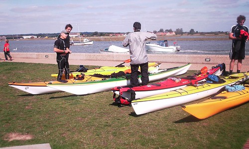
A typical kayakers lunch stop.


Approaching Maldon quay


On the whole, I think that these trips though the summer? months have been quite successful. Occasionally they have been hard paddling, they have given more than one person the opportunity to get out when otherwise they may not have done so. It’s also been good to explore some different parts of the coast and I’ve learnt some lessons along the way. I may well be boat less now for as short a period as I can manage. Once that is sorted out I will arrange some more trips maybe one a month or so. Some of the suggestions that have been made are, around Portland Bill, a weekend circumnavigating the Isle of White (keep meaning to do that one still haven’t) the Thames tideway and even a winter paddle on the Norfolk broads. Who knows a few further flung weekenders could be on the cards, Lundy, The Stacks, Lleyn peninsula.

Weymouth to Lulworth Cove

Well that was a good one. Eight of us on this trip, I will not do a role call as I’m bound to get at least one name wrong. To paddle below the cliffs of the Jurassic Dorset coast at least once a year has to be a must do paddle for anybody in our region, I’m sure that a basic knowledge of geology would have made it all the more interesting.

Following yet another long drive for a good number of us we met at Bowleaze Cove car-park, which purely by chance, turned out to be a popular launching site with at least one other group turning up at the same time. We finally got on the water, regulation thirty minutes late, just as well that there are no real tides to worry about along this stretch of coast

The weather was exactly as forecast force two or less with a clear sky. This all led to one of those balmy relaxed paddles, taking in the sights along the base of the cliffs and stopping for plenty of photographs. It’s not until you take a reference point, such as gulls at the cliff top that it registers how high these cliffs are. We passed under the arch at Bats head and dodged the snorkels in Man-o War bay, before arriving at Durdel Door. Durdel Door always creeps up on me just appearing as a rocky outcrop until I’m right on top of it. On to Lulworth for a relaxed lunch, at the far quieter end of the cove.

On the return trip, just as forecast, the wind rose slightly to a moderate three for a short period, giving rise to a few small waves just to keep us awake. We arrived back at the launch point at 4:30pm pretty much as expected.

Once more thanks for the good company of all those that attended.


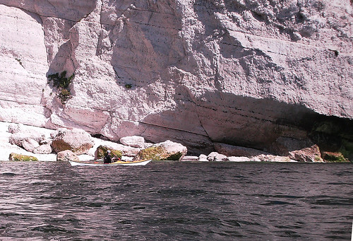
Below the chalk cliffs.


just to give it a bit of scale.


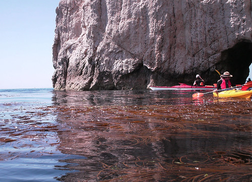
through the arch at Bats Head.
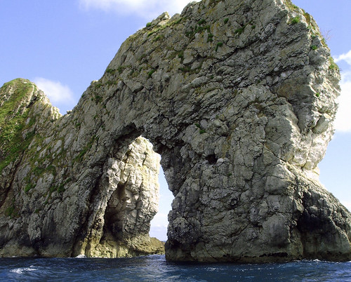

Durdle Door.

Norfolk 29th June 2008

The plan was to meet at Burnham Overy at about 9:30am. Set up a shuttle and then paddle from Cley beach, back to Burnham Overy, via Blakney harbour and Wells. The weather forecast was for a light, south westerly force three or low force four wind, overcast sky with a small chance of showers late in the afternoon. One of the forecasts said rising force five after six pm. This meant that the wind would generally be of a light nature on our port bow quarter.

The plan worked perfectly, except that in good SESK tradition things are never quite that straight forward.

Through no fault of their own three people had to drop out at the last minute, so it was just Grazie and myself. After an early start we met at the allotted car park. Following some brief introductions and moving kit around we made our way to Cley beach. At Cley we duely paid our car park entry fee, which, I later didn’t feel so bad about, having noticed that it went toward the Norfolk Wild life trust, and the up keep of Blakney reserve.

Off we set, with a gentle swell and the usual talk of boats and previous trips. The Turns were diving for food all around and we made good time to Blakney point. Approaching the shallows at the harbour entrance there was a noticeable surf rising up over the sand banks, so we continued to the buoyed deep water channel before turning into the natural harbour. We now came to the first highlight of the day, paddling through the seal colony. We seemed to have timed it quite well, with a rising tide, there were literally hundreds of seals grouped on to rapidly reducing sand banks. There appeared to be both common and grey seals ranging in colour from some substantial looking, almost black males, to young cubs that still retained the last of their white coats. Unfortunately due to technological failure, I have no photographs so we will have to make do with a down load.


Having then bumped into, and had a short chat, with a kayaking dog, who was accompanied by a couple of humans, we were swept by the tide around to the old lifeboat station. Here we stopped to explore. Picked our way over the muddy foreshore and visited the blue tin, lifeboat station now turned into a local museum.

Back on the water the tide had risen enough for the trip boats to get out of Blakney quay, two passed us on the paddle back out of the harbour. As we paddled I looked around and noticed that Grazie had a large tail in the form of a seal following him within inches of his stern, others swam around and under us through quite clear and surprisingly warm water. And now the fun began. This is to be the longest leg of the trip being six and a half miles around low laying sandbanks to Wells beach. The wind was now increasing to a strong four possibly even climbing to a five. We had to stay off shore a bit, to avoid the surf and spray, which added to the distance. The waves built from a gentle swell to a two or three foot chop. As we paddled into the wind my GPS was reading two and a half miles an hour, not even knots.

It was becoming evident that Grazie was the stronger paddler, as he was pulling ahead slightly. I still hadn’t fully recovered from having a cold for the previous two days. At least that’s my excuse and I’m sticking with it. I think that we were both quite pleased when we arrived at Wells beach for a latter than planed lunch break. Sitting on the beach it was quite a pleasant afternoon and the wind seemed to have dropped, even if it was a bit overcast.

Last leg of the day a five and half mile gentle paddle along the beach, in the afternoon sun taking in the sights, or so I thought. It started off like that, then after about fifteen to twenty minutes, the head wind started to build, and kept building. A strong four, then a five. Did it stop there? No it kept building to a to a solid force six. It was partly coming off of the land so no great waves but lots of white caps and spray to keep us awake. Then the heavens opened. I would be hard pushed to call it rain, it was more just water pouring out of the sky. Visibility went down to less than a couple of hundred yards and my GPS was reading just over one mile an hour. After an hour or so of this getting nowhere rapidly. I had had enough and headed into the beach. I decided to trolley the last three or four hundred yards to Burnham creek, while Grazie continued to paddle just off shore. Having reached the creek, about twenty minutes latter, which must have been very hard to spot from the sea, being little more than water running over the beach. The wind had now dropped the rain had stopped and suddenly the sun shone.

Due to the wind and the consequent slow pace, we were now considerably later than intended and the tide in the creek was outgoing at quite a pace. Some amusement was had trying to battle against the current, which led to some of the wrong sort of paddling taking place. Once we reached the first corner the flow dropped and a gentle paddle pursued for the last mile or so back to the car.

All in, an interesting and memorable first SESK trip of 2008 and one that had everything. Lots of wild life, Seals, Terns I even spotted an Eget in the dying moments of the trip. Lots of weather from bright sun and surf to a howling gale and torrential rain. And by no means least good company.

Milford-on-Sea and the Needles 13th July
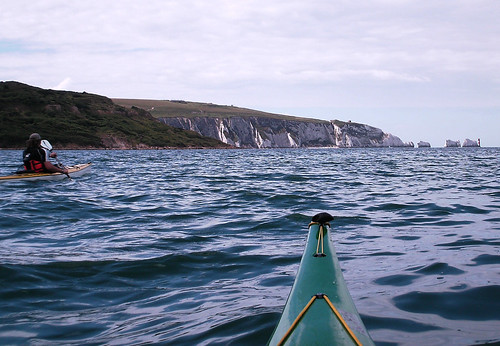
Which became Lymington Harbour to the Needles,. Three paddlers on this trip, myself, (Gunner) Graham and Peter Hennessay. Once more an early start for the 150 mile drive to Lymington, this doe’s have the advantage of clear roads all the way and we arrived nearly half an hour early. Following a strong cup of coffee and a slightly greasy bacon and egg bap from a local cafĂ©, Graham and I met Peter at the planed location.
After my usual faffing around with bits of kit, we were on the water maybe ten minutes latter than planned, which in my book counts as on time

A straight forward paddle over to the island ensued, we remained just outside the deepwater channel coming out of Lynmouth and then took a heading of 190 degrees to pass close to fort Albert, before altering course to cross Totland bay. On the way over we keep a constant watch for other traffic but being at the quieter end of the Solent and still quite early, we generally had plenty of space. Considering that it was a neap tide and we were paddling into an admittedly very light breeze, when I looked down at my GPS I was surprised to see that we had clocked in excess of six and a half Knots. I can begin to see how it is possible to do the sixty-nine mile circumnavigation of the island in a single day. Having arrived at Alum bay early, we took a lunch break, while we waited for the slack tide, before going on the Needles. Not having paddled around the Needles before, two points took my attention. I’ve known, for some time that there is a military establishment on the cliff top, but was quite surprised to see, what I took to be gun emplacements, at close to water level. These could only have been tunnelled down to from above and cut from inside the cliff face. Secondly I was taken by how sharp the upper edge of the Needles stacks are.

As the sun had now shown its face we briefly stopped back in Alum bay to shed a layer of clothing, before, making the crossing back to Lynmouth. We followed a very similar route to the journey out, but now that the tide had turned and the wind had built slightly, the tide race between Hurst spit and the island was flowing nicely, and the water was quite confused. At one point I had to call on my bracing for much more than a bit of extra support. Remembering this was a neap, I would be wary of crossing here on a spring tide. Once across the race and behind the spit the water settled down and with a good force three and the tide behind us we made good time back to Lynmouth.

All in a good trip, the weather was exactly as the forecast predicted although a little more sun would have been good. Again good company, and thanks to those who came along. Below a few photos


Crossing the Solant


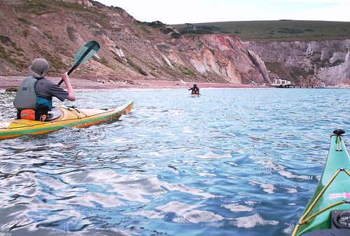
Approaching Alum Bay


Aproaching the Needles
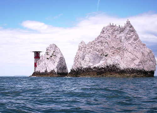


Around we go


And back to Lynmouth